|
RESIDENTIAL LAND
USES
The key policy under which residential land uses
are proposed is LUP Policy 10, which states:
New subdivisions which create
commitment to development immediately adjacent
to environmentally sensitive habitat areas shall
be allowed only at densities compatible with
protection and maintenance of these resources.
New subdivisions may be approved only where
potential adverse impacts to environmentally
sensitive habitats can be prevented. Conformance
to the applicable OSAC maintenance standards
shall be required whenever open space lands
would be affected. No residential subdivision
shall be allowed unless it is first demonstrated
that, for each new residential lot, normal
residential development, including driveway and
utility connections is feasible without damage
to environmentally sensitive habitat.
In order to ensure the preservation of on site
resources, the following zoning designations by
Measure A and residential land uses are
proposed:
*Establishing area K for improvement with
one single-family dwelling will require a Parcel
Map to separate a 2.95-acre residential area
from the adjacent golf course parcel. The
balance of Area K will be placed in a
recreational easement pursuant to its existing
use for golf course and accessory purposes.
Refer to the project data summary sheet for a
comprehensive list of proposed land uses and
densities for each area.
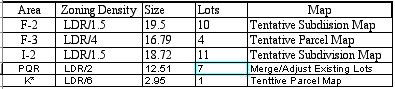
Area F-2
This 19.5-acre single record lot site is
located in the Gowen Cypress Planning area and is
surrounded by the Poppy Hills Golf Course on the
north, east and west. To the south is 17-Mile
Drive/Lopez Road and the entrance to Poppy Hills
Golf Course. The terrain is gentle, sloping, to the
west. Primary vegetation consists of dense
chaparral understory and an even-aged stand of
mature Monterey pines. Isolated Gowen cypress and
Bishop pine are also present on the site An
existing trail runs along the western edge, cutting
across the proposed site access road.
The site is currently planned and zoned for
Medium Density Residential Development (MDR/B-8
(CZ). The DMF LUP allows a maximum of 39 lots with
a density of 2 units per acre. Measure A proposes
an LUP designation and zoning, of Low Density
Residential, 1.5 acres per unit LDR/1.5 (CZ). The
site will be improved with 10 residential lots, two
open space parcels and a right of way parcel.
Average lot size is 1.99 acres per unit. Lots are
of sufficient size to allow the establishment of
building sites to avoid identified Gowen cypress
and Bishop pine trees. Access to individual
residential sites would be provided via an internal
road with access from Lopez Road.
Area F-3
This 16.79-acre single record lot, located
in the Gowen Cypress Planning Area, is bounded by
proposed Open Space Forest lands (Area H) across
Lopez Road (17-Mile Drive) on the south, Poppy
Hills Golf Course on the north and west, and the
contiguous areas of the Huckleberry Hill Natural
Habitat Area/S.F.B. Morse Botanical Reserve.
Several large lot residences are located to the
east across Sunridge Road. The terrain in the
southern portion of the site is gentle and slopes
to the southwest. The northern portion of the site
is steeper, with slopes of up to 30 percent.
Monterey pine is the predominant overstory species
with varying heights and diameters. A stand of
Bishop pine interspersed with fewer Gowen cypress
is located at the northern end of the site. The
understory is dense, up to eight feet in
height.
Currently the subject area is planned and zoned
for Medium Density Residential Development (MDR/B-8
(CZ). The DMF LUP allows a maximum of 30 lots with
a density of 2 units per acre. Measure A LUP and
zoning designation is Low Density Residential, four
acres per unit (LDR/4 (CZ)). The site will be
improved with 4 residential lots and 2 open space
parcels. The residential lots will average +1.50
acres each. A single trail runs through the center
of the site, and will be relocated to an existing
easement along the west property boundary.
Residential sites are proposed to be clustered
in the southern portion of the site, with more than
8.5 acres located within two open space parcels
adjacent to existing and proposed Open Space
Preserve lands. This open space will be contiguous
with the Huckleberry Hill Natural Area/S.F.B. Morse
Botanical Reserve Preserve, and the Open Space
Preserve Area H. This undeveloped area will be
placed within a Conservation and Scenic Easement.
Access to each of the residential lots will be
provided via an internal roadway with access from
Lopez Road.
Area 1-2
This 18.72-acre singlE record lot, located within
the Middle Fork Planning Area, has frontage along
Viscaino and Ronda Roads on the South, Poppy Hills
Golf Course to the north and west. The west edge of
the site abuts the Area H open space preserve at
Spruance Road. The terrain is gentle, sloping to
the west. The overstory is primarily Monterey pine
with a mix of Coast live oak. The understory
consists of herbaceous ground cover and scattered
shrubs. An existing trail runs the length of the
site.
Currently the site is planned and zoned for
Medium Density Residential Development (MDR/ B-8
(CZ)). The DMF LUP allows development of up to 37
lots with a density of 2 units per acre. Measure A
propose LUP and zoning designation of Low Density
Residential, 1.5 acres per unit (LDR/1.5). The site
will be improved 11 lots and three open space
parcels, at a density of 1.7 acres per unit.
Primary access individual residential sites will be
from Viscaino and Lisbon Roads.
Area K
This 10.62-acre site located within the
Spyglass-Cypress Planning Area is completely
surrounded by the Spyglass Hill Golf Course. The
site is divided by Stevenson Drive with 3.94 acres
west and 6.8 acres to the east of the Drive. Slopes
on the site are moderate in the north to steep in
the south in association with identified riparian
areas. The site contains both reparian and wetland
resources. The vegetation consists of Monterey pine
with a mix of Coast live oak, with an understory of
mixed shrubs and herbaceous plants. An existing
trail runs the length of the site.
The site is currently planned and zoned for
Medium Density Residential development (MDR/B-8).
The existing DMF LUP will allow development of up
to 22 lots with a density of 2 du/ac. The project
will merge the portion of the site north of
Stevenson Drive with the Spyglass Hill Golf Course.
The area south of Stevenson Drive is designated
under Measure A as Low Density Residential (LDR).
The southwest portion of this site will be
subdivided from the golf course into one
approximate 2.95 acre residential site. The
remainder of the southern site will be placed in an
open space recreational easement consistent with
existing uses.
Area PQR
Pescadero ìP/Q/R is a +/-259 acre site
comprised of 11 legal lots located within the
Pescadero planning area. The DMF LUP designates
portions of this area as Open Space Forest and
Residential, with a development potential of 154
lots at a density of 1 du/ac. Surrounding land uses
include residential development to the north and
west, open space to the southeast, and undeveloped
property at the southwest corner. Surrounding th
subject site is Open Space Forest and residential
(Macomber Estates Subdivision in Area S) to the
south, Sunridge Road to the northwest, Sunset Lane
to the northeast, Spruance Road and Midwood Lane to
the southwest, and Del Ciervo Road and 17-Mile
Drive to the southeast. The terrain is
characterized by gentle to moderately steep slopes.
Slopes of up to 30 percent and more characterize
the eastern half of the site, in a general
north-south direction. Stands of Monterey pine with
a mix of Coastal live Oak create the overstory on
side. The understory consists of shrubs, herbaceous
plants, and low ground cover. Riperian habitat also
exists on this site. Existing trails are located
throughout the site.
Measure A designates all of PQR as Open Space
Forest, except for about 12 acres in tow small
areas zoned for residential use, one off of
Sunridge Road (3 lots) and one off of Griffin Road
(4 lots). Both of these residentially zoned areas
are immediately adjacent to existing residential
development. The existing 11 lots in the PQR area
will therefore be reduced to 7 residential lots,
all of which will be located in areas that are most
appropriate for residential use and preserve the
maximum habitat value for the remaining PQR natural
open space area.
EXISTING RECORD LOTS
Several areas previously proposed for
subdivision are proposed to remain as existing lots
of record and available for residential
development. These areas are not considered part of
the subject application, and are listed and
described here because these sites are the subject
of the Measure A LCP amendment reducing the
potential number of lots in the Del Monte
Forest.
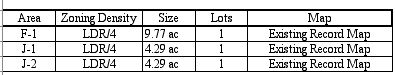
Area F-1
This 9.77 acre single record lot is located in the
Gowen Cypress Planning, Area is bounded by the
S.F.B. Morse Botanical Reserve on the North,
Congress Road on the West, and the Poppy Hills Golf
Course on the South and East. The terrain slopes
gently to the west, increasing to over 30 percent
in the far northwest corner. Dense understory of
chaparral covers much of the site, with a mix of
pine, oak, and cypress as overstory. Existing
trails run throughout the site.
The site is currently planned and zoned planned
for Medium Density Residential Development (MDR/B-8
(CZ)). The current DMF LUP would allow a maximum of
17 lots with a density of 2 units per acre. The
site is proposed by Measure A to be designated for
Low Density Residential development, four acres per
unit (LDR/4 (CZ)), limiting improvements to two
residential building sites. However, the project
proposes to limit development on this site via deed
restriction to one main dwelling with potential for
a caretaker unit or other accessory unit in
accordance with standards contained in LCP Section
20.64.030. Undeveloped portions of the site will be
placed within a Conservation and Scenic Easement.
Existing trail easements are proposed to be
relocated to the eastern edge of the site. exiting
at the far northwest corner, connecting to an
existing, trail along Congress Road.
Area J
The subject site is a 9.38-acre site comprised
of three record lots divided by Spyglass Woods
Drive located within the Spyglass Cypress Planning
Area. The area is bounded by Stevenson Drive on the
west, the Spyglass Hill Golf Course on the
southeast, and existing residences fronting Middle
Ranch Road and Wildcat Canyon Road on the north.
Vegetation on site is primarily Monterey pine and
Coast live oak, with an understory of shrubs and
groundcover. Sensitive riparian habitat has been
identified on site. An existing trail is located in
the northern comer of the area.
Currently the site is planned and zoned for
Medium Density Residential development (MDR/B-8
(CZ)). The DMF LUP would allow a maximum of 22 lots
with a density of 2 units per acre. Measure A
proposes LUP and zoning designations of Open Space
Forest and RC for the center 0.8-acre parcel; and,
Medium Density Residential (MDR/4 and MDR/2 (CZ))
for the remaining two parcels of approximately 4.3
acres, for a maximum total of three residential
lots. The applicant plans no further subdivision of
the two existing legal lots that are zoned
residential, and will place a deed restriction on
each lot limiting any further subdivision. The
existing parcel designated Open Space Forest will
be placed within a Conservation and Scenic
Easement.
EMPLOYEE HOUSING
The proposed project consists of two
components to provide a total of 60 employee
housing units in two separate areas: one near the
Spanish Bay Resort at the southeast corner of 17
Mile Drive and Congress Road, and one near the
Company's corporation yard office complex off
Sunridge Road at the intersection with Lopez
Road.
. Spanish Bay Employee
Housing: This project is located within
a 3-acre (zoning boundary) portion of a 22.6
acre parcel bounded by 17 Mile Drive and
Congress Road. Twelve units in four, two-story
buildings are proposed in a 3-acre area at the
southwest corner of 17 Mile Drive and Congress
Road near the Spanish Bay Resort. Entrance to
the subdivision is off Congress Road. Two of the
townhouse buildings are 3-bedroom duplexes. The
other two buildings each contain four units
consisting of two, 2-bedroom units, and two,
3-bedroom units. Covered parking is provided
with each unit (one space for the 2-bedroom
units, two spaces for the 3-bedroom units).
Uncovered additional and guest parking is
provided throughout the site. See
Exhibit D-1 for site statistic
details.
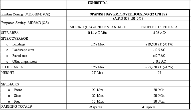
The grading plan for these residential units
will require the removal of 7,500 cy of excess
soil from the project site. Although this
material can likely be used as topsoil or other
beneficial use within the Del Monte Forest, this
material could be transported to the Marina
Landfill. A truck route has been established for
the hauling of soil (Congress Road to S.F.B.
Morse Drive to eastbound Highway 68 and finally
to northbound Highway 1). The construction
impact is discussed in the Transportation
Analysis prepared for this project by Fehr &
Peers Associates, Inc., a copy of which is on
file with Monterey County.
Corporation Yard Employee
Housing. - Forty-eight units in eight
clustered buildings are proposed near the
Company's Corporate yard complex near Sunridge
and Lopez Roads. This project is located on
nearly 14 acres of a 427 acre parcel. Entrance
to the subdivision is off Sunridge Road, just
past the entrance to the Corporation Yard. The
two-story buildings consist of two 3-bedroom
units at each end with four 2-bedroom units
between. Covered parking carports are provided
with each unit (one space for the 2-bedroom
units, two spaces for the 3-bedroom units).
Uncovered additional and guest parking is
provided throughout the subdivision. See
Exhibit D-2 for site
statistic details.
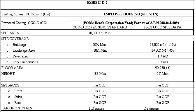
The grading plan for these residential units
will require the removal of 14,000 cy of excess
soil from the project site. Although this
material can likely be used as topsoil or other
beneficial use within the Del Monte Forest, this
material could be transported to the Marina
Landfill. This material will be transported to
the Marina Landfill via Haul Road to eastbound
Highway 68 and finally to northbound Highway I
(with minimal impact to the Forest road system).
The construction impact is discussed in the
Transportation Analysis prepared for this
project by Fehr & Peers Associates, Inc., a
copy of which is on file with Monterey
County.
|