|
PROPOSED GOLF
COURSE
The proposed golf course is situated on
approximately 240 acres located within two LUP
planning areas, the Spyglass Cypress Planning Area
(LUP subareas M, N, and 0) and the Pebble Beach
Planning Area (LUP subareas U and V). Developed
areas of the site include the 43 acre Equestrian
Center/Collins Field and residence areas, the 4.87
acre driving range, the 4.35 acre Spyglass Quarry,
and 5.46 acres of paved roadways including portions
of Stevenson Drive, Drake Road, and Portola Road.
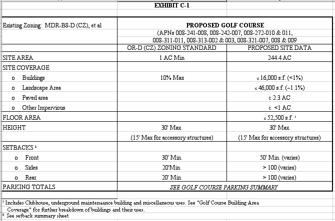
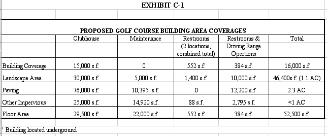
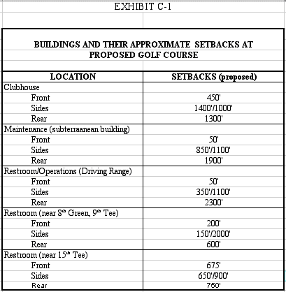
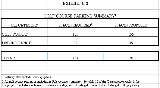
See Exhibit C-1 for site statistic
details and Exhibit C-2 for parking
summary.
The purpose of this element of the project is to
expand the options for visitor serving recreational
uses in the Del Monte Forest consistent with one
component of the major themes established in the
LCP for coastal related uses in the area. The
purpose of the golf course is to utilize existing
natural resources on the site to establish an
environment consistent with standards set for world
class, championship golf and to ensure playability
for coastal visitors.
Consistent with this purpose, the design of the
golf course is intended to achieve several
objectives:
- Avoid, protect and enhance delineated
wetland habitat
- Avoid, protect and enhance dune habitat
- Avoid significant disruption of Yadon's
Piperia habitat
- Avoid significant disruption of Pacific
Grove Clover habitat
- Limit the removal of Monterey Pine forest to
only that necessary to achieve the purpose of
the project
- Control the use of fertilizers and
pesticides to eliminate the potential for
contaminants to enter the Monterey Bay Marine
Sanctuary.
- Minimize the potential for golf course
runoff from entering Carmel Bay ASBS
- Maximize use of existing roadways and
disturbed areas to provide flexibility to
achieve the above objectives. Provide for
continued public trail access.
- Provide additional public restroom and
parking at the renovated driving range across
from Peter Hay Par-3 Golf Course.
The following description is organized according
to the three predominant characteristics of the
site: quarry site (north), former residential/urban
forest site (central), existing, open space
recreation uses (south).
The northern portion of the golf course site is
a significantly disturbed and altered dune
environment surrounded by open space of the
Spyglass Hill Golf Course and Cypress Point Golf
Course, on the north, west. and east, and planning
subarea ìNî on the south.
Historically, this area is known as the Signal Hill
Dune, and has historically been used as a sand
mining area and for outdoor recreation (including
an area for skeet shooting). LUP development
subarea "M" comprises 25.5 acres. Within this
development area, approximately 6 acres have been
designated as a Rehabilitation Area for intensified
development. Within the rehabilitation area, a
4.43-acre portion of the dune has been heavily
mined and is now actively used to stockpile grading
spoils. Of the remaining, area "M" acreage,
approximately 8.2 acres are suitable dune habitat
mapped as ESHA and approximately 2.4 acres are
degraded with a potential for improvement. The
remaining 25 acres of the Signal Hill Dune outside
of subarea "M" are proposed to be enhanced and
restored in accordance with the management
objectives contained in the Dunes section of the
Biological Resources Report. Approximately 35 acres
of existing and potential dune habitat are located
within the Signal Hill Dune area.
The design of this area of the golf course is in
accordance with the following LUP policies related
to dune preservation and enhancement:
14. Near environmentally sensitive
habitat areas, the removal of indigenous
vegetation and land disturbance (grading,
excavation, paving, etc.) shall be restricted to
the minimum amount to accommodate development.
This policy shall not restrict the activities of
the Del Monte Forest Foundation in implementing
OSAC Plan maintenance standards.
18. Uses of the remnant native sand dune
habitat shall be limited to low intensity
scientific, educational, or recreational
activities dependent on the resource, except in
Spanish Bay rehabilitation area, where policy 93
shall apply. Particular attention shall be given
to protection of rare and endangered plants from
trampling. Conformance to the appropriate OSAC
maintenance standards shall be the criteria for
consistency with this policy. Such uses must be
consistent with the restoration and enhancement
of the habitat.
92. Certain areas have been mined for
silica and other minerals and are in need of
rehabilitation. These areas are the most
suitable for more intensive development, as
compared with other forested and undeveloped
land. Consequently, those areas should be
assigned higher densities or permitted the
development of needed visitor accommodations,
recreation facilities, corporation yards, public
works facilities and neighborhood shopping
areas. The more intensive use of these areas
will also provide the incentive to rehabilitate
the previously mined areas and consequently
repair the damage.
Golf hole 15, a portion of the golf hole 16,
golf hole 17, and the proposed golf cottages are
proposed to be located within the rehabilitation
area. Golf course improvements are designed to
protect designated dune ESHAs and incorporate
features compatible with the adjoining natural dune
areas.
The central portion of the golf course site
comprises LUP subareas "N", "O", "V" and "U".
The area is bounded by area "M", the Signal Hill
Dunes and Bristol Curve Road on the North, Forest
Lake Road on the East, the Cypress Point Golf
Course and Sombria Lane on the west, the grounds of
the existing equestrian center/Collins Field and
the existing driving range on the south. The area
is primarily an urbanized forest environment
previously zoned for residential development, with
varying types and density of understory
vegetation.
Although not a significant determinant of
overall habitat type in this area, wetlands have
been delineated in the central portion of the golf
course. Wetlands exist due to the slope of the
land, and the relative depth of permeable and
impermeable soils. This area of the golf course
site possesses slopes from 2% to 9%, with some
areas along the western portion of LUP subarea "N"
near subarea "M" reaching 30 percent. Soils on the
site are Generally shallow sands, which overlay a
dense clay layer. During the rainy season and
extending into the spring off site runoff,
generally from residential areas to the northeast,
is impounded on the proposed golf course site
before discharge into the Cypress Point Golf Course
drainage system. These wetlands have been
delineated as referenced in the Wetland Section of
the Biological Resources Report.
This area contains the majorlty of the 128.7
acres of Monterey pine forest on the site, but that
forest is fragmented by existing roadways that
divide the site, including Stevenson Drive, Portola
Road, and Drake Road. The design of the golf course
utilizes the alignment of these existing breaks in
the forest to minimize tree removal, avoid wetlands
and maintain wetland hydrology, incorporate wetland
buffers, and reduce impacts to sensitive plant
species in this area (see biological reports).
Approximately 5.5 acres of pavement will be removed
for this purpose. Bristol Curve will be eliminated
and Stevenson Drive realigned to intersect with
Forest Lake Road. The resulting improvements will
result in the removal 51.967 acres of Monterey pine
forest, and an additional 6.08 acres of cleared
understory (see Forest Section of the Biology
report for analysis of the number and location of
trees proposed to be removed).
The majority of the 4.3 acres of wetlands
located on the site, are found in this area. The
arrangement of fairways, tees, and greens are
arranged to avoid all wetlands and maintain
appropriate buffer zones. Aspects of the project
are consistent with the following LUP policies:
8. Environmentally sensitive habitat
areas that are not designated as rehabilitation
areas shall be protected against significant
disruption of habitat values
9. Improvements to facilitate recreational
or visitor uses, including vegetation removal,
excavation, grading, or filling in designated
environmentally sensitive habitat areas, shall
be sited, designed and managed to avoid any
significant disruption of the protected
resources. Areas, which are especially sensitive
to recreational use, include riparian habitats,
wetlands, and sites of known rare and endangered
species of plants and animals...
27. A setback of 100 feet from the
landward edge of wetlands and from the mean high
water line of the ocean shall be provided. No
landscape alterations will be allowed in this
setback area unless accomplished in conjunction
with restoration and enhancement and unless it
is demonstrated that no significant disruption
of environmentally sensitive habitat will
result.
Accordingly, the Wetland section of the
Biological Resources Report identifies delineated
wetlands, assesses habitat values, evaluates
hydrologic function, and proposes restoration and
management objectives to increase the viability of
these habitats and to avoid any significant
disruption of their habitat value.
The southern portion of the site
encompasses the existing 43 acre Equestrian
Center/Collins Field/Collins residential area
located north and south of Ondulado Road,
respectively, and to the east of Stevenson Drive, a
10.7 acre area east of Stevenson Drive comprising
the existing driving range, putting, green, and
stands of fringe Monterey pine devoid of forest
understory.
This area of the site is nearly flat and is
characterized by recreational use involving ongoing
equestrian and golf uses and periodic staging and
support for special events historically held in the
Del Monte Forest. Golf course improvements will
involve the removal of all structures and existing
uses related to the Equestrian Center and the
Collins residential site (residence and two
cottages). The existing Equestrian Center will be
relocated to the Sawmill Gulch sand borrow site.
The entire Equestrian Center/Collins Field area
will be recontoured and restored with 15 acres of
replanted pine forest and golf course landscaping.
The existing driving range will be expanded and
reconstructed in its present location, and a small
parking area, public restroom and operations
building will be constructed with access from
Ondulado Road at Stevenson Drive.
The design of golf holes in this area features
east/west trending fairways. This area will
accommodate relocated pine forest as well as newly
planted areas to frame the fairways. Restoration
and enhancement of golf course areas adjacent to
wetlands will be in accordance with the wetland
management plan contained in the biological
resources report. These wetlands will be enhanced
in accordance with management objectives in the
Wetland section of the Biology Report.
Clubhouse Design. The proposed
one-story (plus basement) clubhouse is accessed
from Forest Lake Road and includes uses typically
associated with a golf clubhouse: retail space,
starters desk, office space. a small restaurant and
lounge area, kitchen. storage, and locker rooms,
with on-site parking. The basement level will be
used for golf cart storage, employee areas, and
additional storage area. This low profile building
will have cedar shingle siding with Class "A" fire
retardant composition cedar shingle roofing.
Driving Range Operations Building,
The driving range will be improved by lengthening
and widening of the practice fairway and creation
of a second tee box area nearest the clubhouse for
the proposed golf course. The existing southern end
of the driving ran-c will require relocation of the
tee box area and construction of a ranc7e
operations building to include a public restroom,
storage area, and ball machine, along with a
parking area.
Maintenance Building. The
maintenance building proposed for the golf course
will be located below grade with access from Forest
Lake Road. This underground facility will include
maintenance and repair areas, office space, and
parking for maintenance and employee vehicles.
Additionally, fuel dispensing, equipment washing,
and storage bins will be constructed at grade level
above the underground facility.
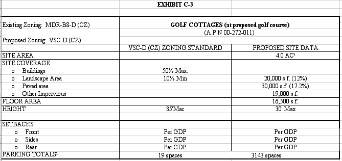
Golf Cottages. The purpose of this
portion of the project is to expand the variety of
visitor serving accommodations by utilizing a
portion of the designated rehabilitation area in
the manner suggested by LUP for such areas. Eleven
new visitor serving, cottages with a total of 24
bedrooms are proposed to be developed near the
intersection of Spyglass Hill Road and Stevenson
Drive. The site is a four-acre portion of the
larger golf course site proposed by Measure A to be
rezoned from Medium Density Residential
(ìMDR-B8-D (CZ)") to Visitor Serving
Commercial ("VSC") to accommodate these units. Of
the eleven cottages proposed, ten will be 2-bedroom
single-story units and one will be a 4-bedroom
two-story unit. . All cottages are designed with
common areas and have decks and patios. The on-site
parking area can accommodate 31 vehicles. The
cottages have wood siding and Class "A" fire
retardant composition shake shingle roofing.
See Exhibit C-3 for site statistic
details.
Grading. Grading for the golf
course is primarily due to the recontouring, of the
site to accommodate the golf course and the
excavation for the underground maintenance
facility, but also includes the minor amount of
grading that is required for foundations and
footings of the new course-related buildings. The
grading plan for all golf course related
improvements indicates an excavation cut of 318,000
cy and a fill requirement of 377,000 cy. The fill
requirement will be met from the on-site excavation
materials, from use of excess excavation materials
from other project components, and from the
importation of drainage and soil amendments
required as a standard feature of golf course
construction. From an overall traffic perspective,
the net impact of these cut and fill components
will be a balanced cut and fill for the golf course
site. The construction traffic impacts are
discussed in the Transportation Analysis prepared
for this project by Fehr & Peers Associates,
Inc., a copy of which is on file with Monterey
County.
|